

The Salar de Uyuni is the world’s largest salt flat, covering 10,500 sq km of south-western Bolivia with salt to a depth of 120m in places. It contains 7% of the world’s lithium reserves (Elon Musk, listen up!) and is one of those must-see places on the must-see places list you read about in magazines. The attraction is partly down to the strangeness of crossing 120km of what is, effectively, a blindingly white chequerboard. But equally that, when it rains (and the wind isn’t blowing), the surface turns into a giant mirror reflecting the sky and surrounding mountains. Great for photos, if not for cycle-touring.
The Salar is also a bit of a Mecca for adventure cyclists (when it’s dry), offering an opportunity for a two-day crossing via the Isla Incahuasi, a cactus-covered island conveniently located in the middle of the flat. There’s a tradition among hardier travellers, apparently, to cycle part way across the lake stark naked. Fortunately for all concerned, we only hear about this tradition when we’re back in the UK.
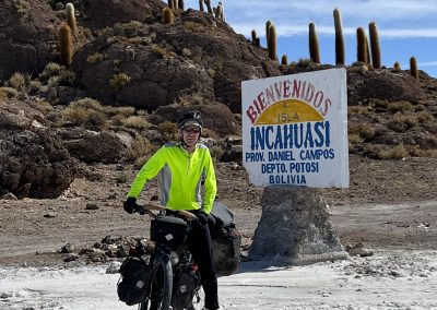
Most tourists have the good sense to visit the flat by car from Uyuni in the east, often as part of a 3/4-day trip across the Salar and into the Lagunas region further to the south. However, as we’re in the pain and discomfort business, we’re planning on cycling from north to south, starting in Tahua and finishing in a place (seemingly) named after a drain cleaner, Tanil Vinto. This is an 80km trip and should take us slightly over a day and a half, depending on winds, road surface and drone activity.
Having crossed the Salar de Coipasa, we’ve some idea of what to expect (flat, white, salty), but are hoping the tourist vehicles have left a highly-polished surface for us to cycle on (tarmac is a distant but fond memory). It’s one of the things about cycle-touring that we spend much of our time fantasising about road surfaces only to be disappointed again and again.
After several days of camping, we arrive in Tahua and check into the Hotel Tayka de Sal. This is a rather posh-looking place on the edge of town, although on closer inspection, it’s a little worn around the edges. Not to worry, it fulfils our basic needs: eating, drinking and transferring dirt and dust onto nice clean towels.
We pop out for supper at the best (and only) place to eat in town, arranging a generous breakfast for the following day before we head out. But, in the morning, the restaurant’s closed and there’s no sign of breakfast. So we go to the baker to buy bread and persuade her to boil us eight eggs (which she’s happy to do, but reluctant to charge for). A little later than scheduled we’re on our way, wrapping ourselves up warmly as the cold air sits on the Salar, like a frosty blanket, first thing in the morning.
The beginning of the flat is marked with posts and a blue puddle of water, which we skirt round before heading down the track. Not many vehicles come from the north, but the “road” is obvious enough even if not heavily used. This is not a problem, as it’s fairly smooth to start with. It’s only later we discover even salt will get corrugated if enough vehicles go over it. On traffic, and everything else, there’s a happy medium.
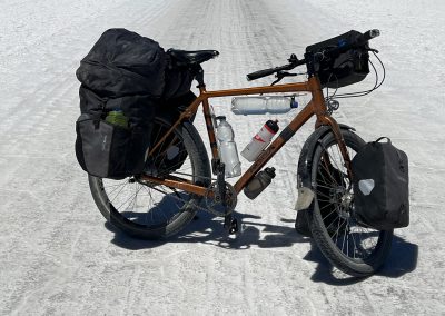
We stop briefly, as Andy has to fix his bar-bag (the rivets holding it together are coming loose) and I have to take some drone footage (otherwise Dronio gets upset). I’m hoping I’ll be able to upload video to my blog but, if there’s a way of doing that, I’ve not yet worked it out. The wind is north-westerly again (long may it last) and we’re making good time, although the road starts to get lumpy and the little blue triangle, showing our progress on my Garmin Explore map, is slowing down to a crawl.
On the subject of hexagons. I’m not an expert on geometry, but it’s hard not to notice that the surface of the Salar is covered in tessellating hexagons. I’d assume these form, on an otherwise smooth surface, when the salt flat is covered with water. As the surface dries, the salt shrinks and pulls apart along the lines of least resistance, leaving hexagonal shapes with shallow depressions around the sides. I’d also speculate that the tyres of the ubiquitous tourist-filled 4x4s flex as they pass over these depressions causing them to get deeper and deeper (rather like the way corrugations form on an otherwise smooth road). The result of this process is, I fear, pain and misery for your average cyclist, but hey ho! we’re born to suffer. Other shapes, such as squares and triangles, tessellate quite nicely too, but for the time being hexagons have the upper hand here. If any hexagonologists out there can explain why this is, please message me at derek.stone@getalife.com.
Around lunchtime we arrive at Isla Incahuasi, where a bunch of tourists are having lunch at salty picnic tables, or luxuriating under silver marquees out on the flat. The wind is blowing strongly now and my envyometer is barely registering as we seek shelter. It can get pretty cold at night, so we decide to camp on the island, forgoing the classic “tent-with-light-inside-against-salt-and-starry-backdrop” photo I’d been planning to take over the last few days. We bump into Bruno and Sophie again; they’ve already nabbed one of the best camping spots. We shoehorn our tent into the space next-door, wedged between a couple of cacti.
A quick circuit of the island by bike gives us the opportunity to take a selection of silly photos involving pots, pans, bottles and bike equipment (see below). I’d thought about packing a giant inflatable T-rex just for this occasion but, fortunately, common sense prevailed.
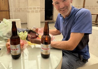
Having paid our fee, we climb to the top of the island to get our sunset shots. We’re then ushered into a nice clean room by the island’s “boss”, where we enjoy the view, drink some beer, and pick up some tips from Bruno and Sophie on how to cook something other than couscous.
The next day we continue south on roads that start badly but end well. So well, in fact, that we set a new Bolivian land-speed record of 15mph. Apart from an unscheduled right-hand turn into an irritating north-westerly (which leads to a causeway taking us off the Salar) the rest of the day is plain sailing and records tumble, including the longest day (45 miles) and most empanadas eaten in 15 minutes (eight).
What did we take away from the experience? First, use plenty of sunscreen and cover up if you’re of a pale disposition. Second, wear sunglasses unless you want to lose your sight for a couple of days. Third, even though it’s perfectly flat, you’ll be convinced you’re cycling uphill most of the time, which is weird. Fourth, check the wind direction before leaving and adjust your expectations accordingly. Fifth, enjoy the moments of solitude when all the tourists have gone. Sixth, take a giant inflatable dinosaur with you, preferably two.
-

The skeleton of a cycle tourist who didn't make it across the Salar
-
Some basic precautions to ensure we don't end up the same way
-

Blue at the start…
-
Didn’t Talking Heads write a song about this?
-
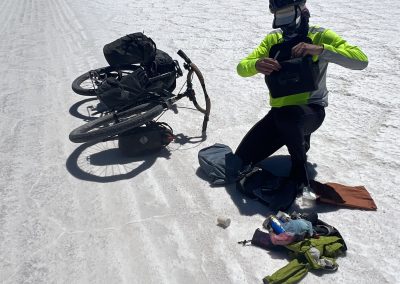
Running repairs on the bar-bag
-

A moth blown off course perhaps
-

Um, yes.
-

…
-

…
-
Home sweet home
-

Well-fed bird
-

One minute the carpark is full. The next minute it's empty
-

It's big!
-
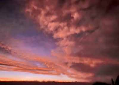
Crazy sunset
-

Warm colours but a cold spot
-

Dawn is also chilly!
-

…green at the end
-
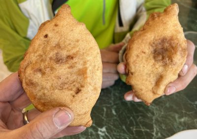
Empanada heaven


